WEATHER WEB SITES
And Other Useful Sources
Don Anderson N6HG
February 20, 2004
Tracking Cruising Yachts in the Pacific.
Daily at 0325Z on 14313.0 KHz
Posted to website (http://www.bitwrangler.com/yotreps/) each evening after roll call with positions, track, weather and chart.
Good source of on-site weather conditions.
High Seas Forecasts East Pacific. NWS Washington DC.
Equator to 60N East of 160W.
Excellent plain text forecast for the big picture out to 36 hours.
Text updated every 6 hours beginning 0500Z.
Available free to all vessels equipped with INMARSAT-C receivers.
California Waters from 60
NM TO 250 NM Offshore.
Point Conception to Guadalupe Island.
Plain text for today, tonight and tomorrow.
Reliable for passages offshore Baja.
http://weather.noaa.gov/cgi-bin/fmtbltn.pl?file=forecasts/marine/offshore/pz/pzz085.txt
High Seas Forecast South Pacific NWS Honolulu
Equator to 25S, between 120W and 160E
Excellent plain text forecast for the big picture out to 36 hours.
http://weather.noaa.gov/cgi-bin/fmtbltn.pl?file=forecasts/marine/high_seas/south_hawaii.txt
Naval Pacific Meteorological and Oceanographic
Center/Joint Typhoon Warning Center.
USN Honolulu. Charts, Satellite Images and Text.
The best graphical predictions for tropical cyclones throughout the world.
Excellent charts and text out to 144 hours updated every 6 hours only when there is a significant cyclonic disturbance.
National Hurricane Center/Tropical Prediction Center
Located on the campus of Florida International University, Miami FL.
Tracks active and potentially active tropical systems.
Most up to date source of analyses and predictions in text form with satellite imagery.
Areas covered:
Atlantic Ocean, Caribbean Sea, Gulf of Mexico and Eastern Pacific out to 140ºW.
http://www.nhc.noaa.gov/index.html
Central Pacific Hurricane Center
NWS, Honolulu, Hawaii.
Analysis and forecasts for all tropical cyclones in Central Pacific, 140W to the International Dateline.
http://205.156.54.206/pr/hnl/cphc/pages/cphc.shtml
Fleet Numerical
Meteorology and Oceanography Center (FNMOC)
US Navy, Monterey, California. (831) 656-4875
Most extensive global weather charts with prognoses out to 6 days.
Home Page: http://152.80.49.210/
Best wind vector forecast for Baja outside and on down to Colombia including Gulf of Mexico. Not much detail for Sea of Cortez.
Click on “(COAMPS) Central America” for numerical model surface wind vector analysis and prognoses out to 48 hours in 6-hour increments.
Click on “Global Models (NOGAPS) and then on “Tropical EASTPAC” for surface streamlines out to 144 hours in 12-hour increments. Covers 40N to 30S and 080W to 160E. Good for best guess long range forecast for Baja outside, Gulf of Tehuantepec, windy areas of Central America such as Gulf of Papagayo and G of Panama.
Best big picture for routes to Hawaii and French Polynesia.
University of Hawaii. Department of Meteorology
http://lumahai.soest.hawaii.edu/cgi-bin/uhmetintro.cgi
Educational and research site so intermittent, especially when the surf is up.
However, when their products are current, they are the best color-coded global GOES satellite infrared images available for the Pacific. Good views of the Pineapple Express.
When reliable they provide frequent updates, sometimes hourly.
GOES-10 Hawaii to U.S. Mainland.
Especially useful for tracking the ITCZ west of 115W, fronts, thunderstorm activity (significant convection) and cyclonic storms (hurricanes etc.).
Click on “Sea Level Pressure and Wind Overlays” to see excellent surface analysis of N. Pacific high with wind vectors. Shows why one should think twice about taking “Clipper Route” from Mexican ports to Northern California.
GOES-10 Pacific West of 105W
Especially useful for tracking the secondary ITCZ south of the equator, west of 105W.
Also good for tracking tropical cyclones in western Pacific
INTELLICAST North Pacific
High Resolution Satellite Image.
Infrared encoded Northeast Pacific image. Chamela Mexico to Alaska and out to 170W updated every 30 minutes.
Good but poor resolution in color encoding. However, it’s very reliable.
National Meteorological Service of México City (SMN).
http://smn.cna.gob.mx/productos/mm5/htm/pag7772.htm
SMN in collaboration with Pennsylvania State University and National Center for Atmospheric Research, Boulder CO.
Uses the Numerical Forecast MM5 model.
Wind vectors for entire west coast of Mexico, including Sea of Cortez and Gulf of Mexico out to 72 hrs.
Updated daily at approximately 0430Z.
Fairly good out to 48 hours, less so for 72 hrs. Overall not as good as FNMOC wind vector prognoses.
http://smn.cna.gob.mx/satelite/sat.html
GOES-8 IR Satellite Image, color-coded. Complete coverage for US, Mexico to Ecuador and the Caribbean. Updated every 30 minutes.
Click on “Loop” to view excellent animation of cloud movement for recent 3-hour period. Useful for estimating rate of movement or dissipation of Pineapple Express and other cloud formations across entire area. By observing the turbulence in the center of high attitude low temperature cloud formations one can assess the degree of convection and hence the strength of TSTM intensity.
Also black and white image of Mexico only, with Gulf of Mexico. Good for Baja Peninsular, Sea of Cortez down to Gulf of Tehuantepec. Updated every three hours.
Eastern East Pacific GOES-8 Satellite Infrared Image, Ch. 4
NOAA color-coded image updated hourly.
Good for tracking cyclonic disturbances and TSTM’s Baja to Panama.
Good images of Pineapple Express when it is crossing the Baja or Mainland Mexico.
30N to Equator, 080W to 110W and Baja-Sea of Cortez.
http://www.ssd.noaa.gov/PS/TROP/EPACIR4.html
East Central Pacific GOES-10 Satellite Image
NOAA color-coded image updated hourly.
Good for Pt. Conception to Cabo San Lucas, including Sea of Cortez.
Also useful for tracking fronts, storms, tropical disturbances and the Pineapple Express.
Equator to 36N, 110W to 160W.
http://www.ssd.noaa.gov/PS/TROP/CPACIR4.html
U of Wisconsin, East
Pacific color coded GOES-10 Satellite image.
Beautiful color images updated every two to four hours. Another educational and research institution and hence occasional outages. Moderately reliable.
http://cimss.ssec.wisc.edu/tropic/real-time/eastpac/images/xxirg9n.GIF
National Pacific
Meteorology and Oceanography Center, San Diego (USN)
San Diego Local Weather
Eastern Pacific and Central America
Links to other USN sites.
Many other products available from this page.
National Center for Atmospheric Research, Boulder
Colorado.
NCAR Index Page for Real-Time Weather
http://www.rap.ucar.edu/weather/
NCAR Surface Analysis, US to 20N
Only a fair indicator of present conditions for high wind areas such as Ceralvo Channel, Cabo Corrientes and the outside of the Baja. Frequently in error compared to on-site reports.
http://www.rap.ucar.edu/weather/surface/us_mslp.gif
NCAR 12hr Surface Winds, US to 20N
Fairly good prognosis chart, unfortunately only goes out to 12 hours and cuts off at Cabo Corrientes.
http://www.rap.ucar.edu/weather/model/ruc12hr_sfc_mslp.gif
NCAR Surface Winds, US to 20N
Five frames, Analysis, 03, 06, 09, and 12-hour forecasts.
National Research
Laboratory (NRL), Monterey (USN).
http://www.nrlmry.navy.mil/sat_products.html
Spectacular satellite images for Atlantic and Pacific Oceans. Updated frequently.
Marine Observing Systems
Team.
High resolution ocean surface winds derived from the SeaWinds Scatterometer.
Processed by NOAA/NESDIS from near real-time data from NASA/JPL’s SeaWinds Scatterometer aboard the QuikSCAT polar orbiting satellite.
Global wind vectors. Updated frequently, sometimes hourly.
Excellent for Gulf of Tehuantepec and Central America.
Click on chart area of interest for spectacular fine grid wind vector resolution.
By far the best source of reliable accurate data for checking validity of analyses and prognoses for ocean wind vectors from numerical models, 080N to 080S.
When the Multidimensional
Histogram (MUDH) rain flag is being used, the black vectors are a
good indication of the location and degree of severity of the ITCZ.
http://manati.wwb.noaa.gov/quikscat/
NOAA National Data Buoy
Center
Hourly weather from coastal and offshore weather buoys and coast stations.
Excellent for verifying forecasts.
Northwest USA and Canada
http://www.ndbc.noaa.gov/Maps/Northwest.shtml
Southwest USA
http://www.ndbc.noaa.gov/Maps/Southwest.shtml
Hawaiian Islands
http://www.ndbc.noaa.gov/Maps/Hawaii.shtml
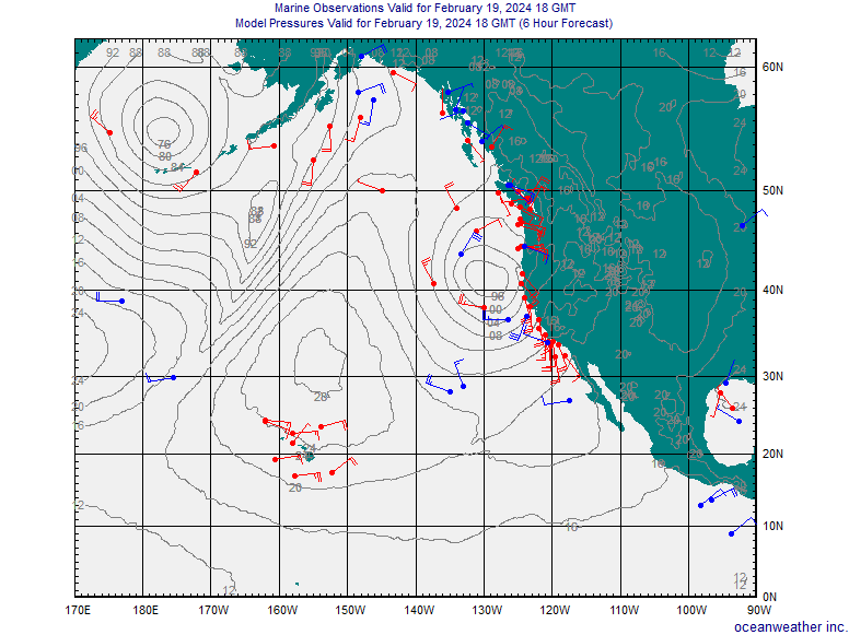
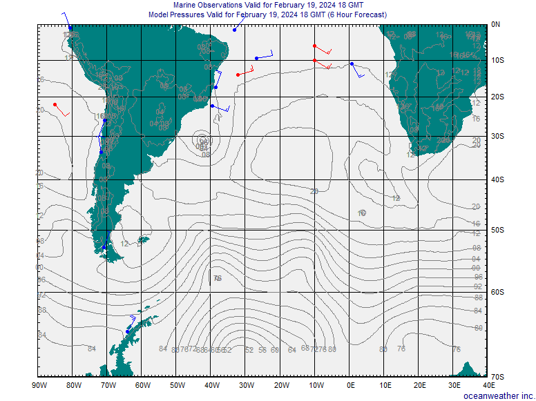
Oceanweather Inc.
Marine forecasts/hindcasts Research at the air-sea interface.
Wind vectors from on-site reports from ships, weather buoys and coast stations.
Global coverage updated every 6 hours.
Excellent reliable data except that occasionally a ship’s report will be a significant error (e.g. N at 60 kts when isobaric charts would suggest S at 6 kts). Therefore need to check against your own wind estimate from isobaric spacing and direction (4 MB spacing in degrees of latitude divided into 50).
Good data for checking validity of analyses and prognoses from numerical models.
Click on bottom right corner to select a region from a world chart.
Northeast Pacific, Equator-62N, 090W-170E
http://www.oceanweather.com/data/NPAC-Eastern/marineM00.gif
Northwest US Coastal, 40-52N, 116-140W
http://www.oceanweather.com/data/NW-US/marineM00.gif
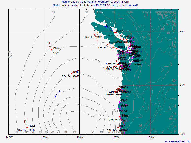
Southwest US Coastal, 30-42N, 116-134W
http://www.oceanweather.com/data/SW-US/marineM00.gif
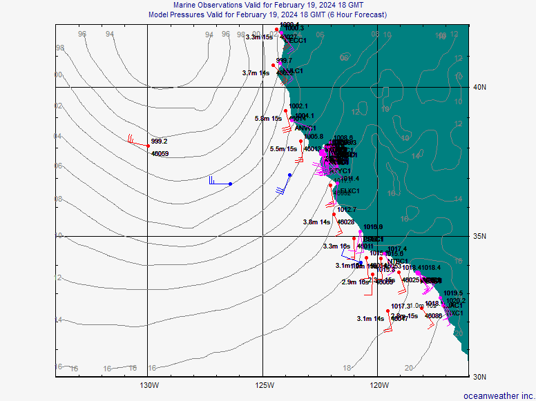
South Pacific, Equator to 70S, 065W-160E
http://www.oceanweather.com/data/South-Pacific/marineM00.gif
South Atlantic, Equator to 70S, 040E-090W
http://www.oceanweather.com/data/South-Atlantic/marineM00.gif
Land-based Meteorological
Stations.
These stations provide a good check on prognoses. They allow one to assess the diurnal thermal effects on coastal conditions. Often winds are much stronger and sometimes 180 degrees different from what one sees on marine weather charts. This is because the charts tend to average wind vectors over 12 or 24-hour periods over areas as great as 100,000 square miles (blocks of 5 degrees of latitude on a side).
Check the following NWS website for worldwide list of stations.
http://www.nws.noaa.gov/tg/siteloc.shtml
Mexico, Hourly Reports
Mexicali 32-38N 117-00W 22m
http://weather.noaa.gov/weather/current/MMML.html
Loreto 26-01N 111-21W 15m
Fairly good read on Southern Sea of Cortez on Baja side.
http://weather.noaa.gov/weather/current/MMLT.html
Guaymas 27-58N 110-56W 27m
Fairly good read on Central Sea of Cortez on mainland side.
http://weather.noaa.gov/weather/current/MMGM.html
Los Mochis 25-41N 109-05W 4m
Fairly good read on Southern Sea of Cortez on Mainland side.
http://weather.noaa.gov/weather/current/MMLM.html
La Paz 24-04N 110-22W
Fairly good read on winds in La Paz area.
http://weather.noaa.gov/weather/current/MMLP.html
San Jose Del Cabo
23-09N 109-42W
Use with caution.
When wind speeds are high, they are usually high offshore. However the wind direction rarely agrees with that across the water.
http://weather.noaa.gov/weather/current/MMSD.html
Mazatlan 23-10N 106-16W
Winds tend to be much less than offshore, unless from the westerly quadrant when they seem to be a reliable indicator of coastwise conditions, especially afternoons.
http://weather.noaa.gov/weather/current/MMMZ.html
Puerto Vallarta 20-41N 105-15W
Rarely a good indicator of winds in Banderas Bay, especially La Cruz and Punta de Mita where afternoon winds are often strong from the west.
http://weather.noaa.gov/weather/current/MMPR.html
Manzanillo 19-09N
103-34W
Very reliable indicator of coastal daytime and early evening conditions in that area, especially the afternoon southwesterlies.
http://weather.noaa.gov/weather/current/MMZO.html
Ixtapa-Zihuatanejo 17-36N 101-28W
Very reliable indicator of coastal daytime and early evening conditions in that area, especially the afternoon southwesterlies.
During winter months, marine forecasts usually show light and variable winds 10 kts or less from Chamela to Puerto Huatulco. However, for this stretch of the mainland, land-based reports as well as those from anchored vessels, show light to calm winds night and early morning, and occasionally 10 to 15 kts off the land. By noon winds veer to the S to SW 5 to 10 kts, and by mid afternoon are frequently SW to WSW 10 to 15 kts, occasionally 20 to 25 kts.
http://weather.noaa.gov/weather/current/MMZH.html
Acapulco 16-46N 099-45W
http://weather.noaa.gov/weather/current/MMAA.html
A light wind area, especially during the winter months. Not a good indicator of winds 50 to 100 NM offshore. Reliable for afternoon southwesterly wind reports.
Puerto Escondido 15-52N 97-05W 88m
http://weather.noaa.gov/weather/current/MMPS.html
Good indicator of on coastal winds between Acapulco and Bahias de Huatulco.
Bahias De Huatulco 15-47N 096-16W
http://weather.noaa.gov/weather/current/MMBT.html
Located on the west end of the Gulf of Tehuantepec, but not
a good indicator of conditions in the Gulf. Winds are usually from the southern semicircle less than 15
knots. Even when there are gale or storm conditions in the Tehuantepec.
Minatitlan 18-06N 094-35W
http://weather.noaa.gov/weather/current/MMMT.html
Located on the Bahia de Campeche on Atlantic side of the Tehuantepec.
A good indication of conditions in the Gulf of Tehuantepec.
If it’s blowing 15+ from the northerly quadrant, then it’s probably blowing a gale in the Tehuantepec. When it’s blowing from the other quadrants, it’s usually light and variable in the Tehuantepec.
(By far the best 2- and 5-day forecasts for the Gulf of Tehuantepec may be found in the USN FNMOC COAMPS and NOGAPS Tropical East Pacific Surface Streamlines and Wind Speeds graphics at https://www.fnmoc.navy.mil/PUBLIC/
Meteorological Stations,
Central America, Hourly Reports
San Jose, Guatemala 13-55N 090-49W 2m
Fair indication of conditions in Puerto Quetzal.
http://weather.noaa.gov/weather/current/MGSJ.html
Compala, El Salvador 13-26N 089-03W 25m
Fair indicator of conditions at Marina Barillas.
http://weather.noaa.gov/weather/current/MSLP.html
Chinandega, Nicaragua 12-38N 087-08W 60m
Good read on wind direction but coastal winds often stronger than reported.
http://weather.noaa.gov/weather/current/MNCH.html
Bluefields, Nicaragua 12-00N 086-46W 5m
Useless indicator of winds on the Pacific side.
http://weather.noaa.gov/weather/current/MNBL.html
Liberia, Costa Rica 10-37N 085-26W 80m
The best read on Gulf of Papagayo winds, but often coastal winds are stronger by as much as 15 kts with much stronger gusts.
http://weather.noaa.gov/weather/current/MRLB.html
Chacarita, Costa Rica 09-59N 084-47W 2m
Only 5 miles east of Puntarenas. Good reliable reports.
http://weather.noaa.gov/weather/current/MRCH.html
Tobias Bolanos International, Cost Rica 09-57N 084-09W 994m
Located 100 miles ESE of Gulf of Papagayo and 36 miles N of Punta Quepos.
A fairly good indicator of winds along the coast, especially
if strong from E to NE.
http://weather.noaa.gov/weather/current/MRPV.html
Santiago, Panama 8-05N 080-57W 88m
Located on peninsular at west side of Gulf of Panama. Best indicator of the strong winds prevalent off Punta Mala. Daytime winds usually 5 to 10 kts greater than marine forecasts. Night and early morning winds usually calm or much less than marine forecasts.
http://weather.noaa.gov/weather/current/MPSA.html
Marcos A. Gelabert, Panama 08-59N 079-31W
Good indicator of Canal Zone weather
http://weather.noaa.gov/weather/current/MPMG.html
Tocumen, Panama 09-03N 79-22W 45m
http://weather.noaa.gov/weather/current/MPTO.html
Good indicator of Canal Zone weather
NWS CHARTS
Also broadcast as WEFAX charts by USCG stations.
Eastern Pacific Wind/Seas Analysis. Tropical Prediction Center/TAFB Miami FL.
34N to 20S between 075W and 140W
Effective January 24, 2001 upgraded to provide forecasts out to 24 hours. Updated every 12 hours. Good reliable wind vector data for long offshore passages:
Hawaii to Marquesas
Mexico to Hawaii
Mexico to Marquesas
Banderas Bay offshore to Panama and South to Galapagos.
Not very good for coastal conditions.
Poor and unreliable coverage for Sea of Cortez. Often 24 hours late for gale warnings in the Gulf of Tehuantepec.
Best source of wind data for Marquesas bound vessels equipped only with WEFAX. Available as WEFAX from USCG Station NMC, Point Reyes.
Frequencies, USB: 4344.1 8680.1 12728.1 17149.3
Times UTC: 1510 2419
http://weather.noaa.gov/pub/fax/PJBA00.TIF
http://weather.noaa.gov/pub/fax/PJBA01.TIF
24-Hour Wind/Wave Forecast
Northeast Pacific, Alaska to Cabo San Lucas
Valid 0000Z.
http://weather.noaa.gov/pub/fax/PWBE98.TIF
Valid 1200Z.
http://weather.noaa.gov/pub/fax/PWBE99.TIF
48-Hour Wind/Wave Forecast.
Northeast Pacific, Alaska to Cabo San Lucas
Valid 0000Z.
http://weather.noaa.gov/pub/fax/PJBI98.TIF
Valid 1200Z.
http://weather.noaa.gov/pub/fax/PJBI99.TIF
Pacific Surface Analysis.
Isobars, wind vectors and fronts; northeast Pacific.
18N to 65N and 118W to 173W
Valid 0000Z.
http://weather.noaa.gov/pub/fax/PYBA01.TIF
Valid 0600Z.
http://weather.noaa.gov/pub/fax/PYBA03.TIF
Valid 1200Z.
http://weather.noaa.gov/pub/fax/PYBA05.TIF
Valid 1800Z.
http://weather.noaa.gov/pub/fax/PYBA07.TIF
24-Hour Surface Forecast.
Northeast Pacific, isobars and fronts. No wind vectors.
Valid 0000Z.
http://weather.noaa.gov/pub/fax/PPBE00.TIF
Valid 1200Z.
http://weather.noaa.gov/pub/fax/PPBE01.TIF
48-Hour Surface Analysis.
Isobars, wind vectors and fronts; entire north Pacific.
22N to 65N and 118W to 138E
Valid 0000Z.
http://weather.noaa.gov/pub/fax/PWBI98.TIF
Valid 1200Z.
http://weather.noaa.gov/pub/fax/PWBI99.TIF
96-Hour Surface Forecast.
Isobars, wind vectors and fronts; entire north Pacific.
22N to 65N and 118W to 138E
Valid 0000Z.
http://weather.noaa.gov/pub/fax/PWBM99.TIF
Mexico Weather. USA Today. Chart
Moderately useful for showing thunderstorm areas but otherwise of no marine value.
http://www.usatoday.com/weather/basemaps/wmxp1.htm
Mexico Weather. USA Today. Selected Cities.
Designed for tourists. 4-day forecasts for wind, cloud cover and precipitation. Rarely accurate except during really bad weather.
http://www.usatoday.com/weather/basemaps/wmxt1.htm
High Seas Forecast, Offshore Peru NWS Washington DC.
S Pacific from the Equator to 18.5S E of 120W.
Galapagos and offshore Ecuador and Peru.
Plain text forecast out to 36 hours, updated every 6 hours beginning 0515Z.
Available free to all vessels equipped with INMARSAT-C receivers.
http://weather.noaa.gov/cgi-bin/fmtbltn.pl?file=forecasts/marine/high_seas/east_pacific_3.txt
Coastal and Offshore Forecast, Chile
Armada de Chile, Valparaiso Playa Ancha Radio CBV.
Coast of Chile to Antarctica and out to 130W.
Plain text forecast out to 36 hours, updated every 12 hours. In Spanish and English.
Available free to all vessels equipped with INMARSAT-C receivers.
Information available from cbvradio@directemar.cl
Twice daily position reports to mrccchile@directemar.cl
GRIB Files
Five-day forecasts: wind vectors
Send the following:
grib:10N,35N,090W,160W|1,1|12,24,48,72,96,120,144,168,192|
or to receive files daily at about
1200Z send:
sub
grib:10N,35N,090W,160W|1,1|12,24,48,72,96,120,144,168,192 days=30
Global 5-Day Marine Forecasts
Interesting virtual buoy data based on numerical models.
Armada de Chile
Copies of daily Analysis and Prognosis WEFAX charts.
Go to Servicios, Servicio de Comunicaciones Marítimos, Meteorolgia, Mapa Sinóptico.
Only source of such information for entire coast of Chile.
Dundee Satellite Receiving Station
Spectacular black and white geostationary satellite images of whole globe.
http://www.sat.dundee.ac.uk/auth.html
USCG HF VOICE BROADCASTS
Perfect Paul synthesized voice weather forecasts
http://www.nws.noaa.gov/om/marine/hfvoice.htm
WEFAX RECEPTION
Currently the simplest system for laptop/PC’s is JVComm32.
All one needs is an HF receiver, the software and a laptop/PC equipped with a sound card. No external demodulator is necessary. The quality of the images is excellent. The software may be downloaded from the website of Eberhard Backeshoff, DK8JV.
List of Worldwide HF WEFAX Stations
Worldwide Marine Radio Facsimile Broadcast Schedules
List of stations, products, frequencies and schedules compiled by NOAA/NWS
Acrobat PDF file.
http://www.nws.noaa.gov/om/marine/rfax.pdf
New Zealand
ZKLF Radio Facsimile Schedule
Schedule of HF WEFAX transmissions.
http://www.metservice.co.nz/services/radiofax_schedule.pdf
INMARSAT-C
NWS, Peru, Chile, Fiji, New Zealand and Australia Meteorological Offices broadcast free marine analyses and forecasts in English text form to vessels equipped with INMARSAT-C transceivers. Excellent information for entire Pacific, updated every six hours by some offices.
See: Trimble Product Guide: Galaxy Inmarsat-C/GPS Marine, for transceiver system details at:
http://www.trimble.com/galaxymarine.html
HF E-mail, WinLink and SailMail
The latest in low cost e-mail for offshore cruisers worldwide.
Necessary to receive GRIP files.
Software is free.
NOAA POLAR ORBITING WEATHER
SATELLITES
Presently the ultimate for real-time visible and color-coded infrared images.
Excellent images of fronts, storms and tropical cyclones. Images allow one to pinpoint severe convection cells.
Each satellite provides at least two passes per day and covers an area of about 1000 miles wide by 3000 miles N to S depending on altitude at time of transit over the receiver’s location.
Requires a satellite receiver, gain antenna, decoder PC card and software.
Presently NOAA 12, 15 and 17 are operational
For current status of these satellites, see:
http://noaasis.noaa.gov/NOAASIS/ml/status.html
See: OCENS, SeaStation Mariner, Satellite Weather, for receiver system details.
LONG RANGE FORECASTS
El Niño/Southern Oscillation (ENSO) Diagnostic
Discussion
NOAA/NWS Climate Prediction Center
Camp Springs, MD
Updated around the middle of each month.
http://www.cpc.ncep.noaa.gov/products/analysis_monitoring/enso_advisory/
The Tropical Meteorology Project
Atlantic hurricane prediction team headed by Professor William M. Gray
Department of Atmospheric Science
Colorado State University
Fort Collins, CO 80523
Phone Number: 970-491-8681
http://tropical.atmos.colostate.edu/forecasts/
TOOLS
VISUAL PASSAGE PLANNER. Software by Digital Wave, 2002.
Presently the best tool for planning optimum tracks for long ocean passages.
User friendly for documenting and printing long passages.
Robert Gehrsitz
P.O. Box 326, Fort Monmouth, NJ 07703
(215) 493-7483 or (877) 783-8591
http://www.digwave.com/index.html
VIRTUAL PASSAGE. Software by Virtual Passages, 2000.
More of a game than a tool, but interesting from the standpoint of learning what passage making is all about.
P.O. Box 13024
Huntsville, AL 35803, (246) 882-9517 FAX 882-9517
HISTORICAL RECORDS
National Hurricane Center/Tropical Prediction Center
Archives of Past Hurricane Seasons
http://www.nhc.noaa.gov/pastall.html
The National Hurricane Center's Tropical Cyclone Reports (formerly called Preliminary Reports) contain comprehensive information on each storm, including synoptic history, meteorological statistics, casualties and damages, and the post-analysis best track (six-hourly positions and intensities).
2000 East Pacific Tropical Cyclone Reports
http://www.nhc.noaa.gov/2000epac.html
2001 East Pacific Tropical Cyclone Reports
http://www.nhc.noaa.gov/2001epac.html
REFERENCE WORKS and TUTORIALS
Fundamentals of Physical Geography
http://www.geog.ouc.bc.ca/physgeog/home.html
National Science Digital Library
Michael Pidwirny, Ph.D.,
Associate Professor
Department of Geography
Okanagan University College
Kelowna, British Columbia,
Canada
Excellent glossary of
meteorological terms.
Hurricanes, Typhoons, and Tropical Cyclones
by Christopher
W. Landsea, NOAA / AOML, 4301 Rickenbacker Causeway
Miami, Florida 33149, chris.landsea@noaa.gov
http://www.aoml.noaa.gov/hrd/tcfaq/tcfaqHED.html
![[Photo of AOML]](My%20Weather%20Sources_files/image002.jpg) The Atlantic Oceanographic and Meteorological Laboratory (AOML) is one
of the Oceanic and Atmospheric Research (OAR) Facilities of the National
Oceanic and Atmospheric Administration (NOAA). NOAA/AOML is a part of the US
Department of Commerce (DOC) and is located in Miami, Florida. AOML's mission
is to conduct basic and applied research in oceanography, tropical meteorology,
atmospheric and oceanic chemistry, and acoustics. The research seeks to
understand the physical characteristics and processes of the ocean and the
atmosphere, both separately and as a coupled system.
The Atlantic Oceanographic and Meteorological Laboratory (AOML) is one
of the Oceanic and Atmospheric Research (OAR) Facilities of the National
Oceanic and Atmospheric Administration (NOAA). NOAA/AOML is a part of the US
Department of Commerce (DOC) and is located in Miami, Florida. AOML's mission
is to conduct basic and applied research in oceanography, tropical meteorology,
atmospheric and oceanic chemistry, and acoustics. The research seeks to
understand the physical characteristics and processes of the ocean and the
atmosphere, both separately and as a coupled system.
National Hurricane Center/Tropical Prediction Center
Archives of Past Hurricane Seasons
http://www.nhc.noaa.gov/pastall.html
The National Hurricane Center's Tropical Cyclone Reports (formerly called Preliminary Reports) contain comprehensive information on each storm, including synoptic history, meteorological statistics, casualties and damages, and the post-analysis best track (six-hourly positions and intensities).
2000 East Pacific Tropical Cyclone Reports
http://www.nhc.noaa.gov/2000epac.html
2001 East Pacific Tropical Cyclone Reports
http://www.nhc.noaa.gov/2001epac.html
TROPICAL WAVES
Tropical Waves by Michel Davison
http://www.hpc.ncep.noaa.gov/international/training/tropicalwaves.old/
Home Page: http://www.hpc.ncep.noaa.gov/international/intl2.html
Excellent 29-frame Microsoft PowerPoint Presentation that may be downloaded.
OCEAN PASSAGES FOR THE WORLD, Publication NP 136, Fourth Edition, Hydrographic Department, Ministry of Defence, Taunton, Somerset, England. Available from Agents for the Sale of Admiralty Charts. The classic authority since 1895.
WORLD CRUISING ROUTES, Third Edition, by Jimmy Cornell, 1995. International Marine, McGraw Hill, P.O.Box 547, Blacklick, OH 43004. 1-800-822-8158.
THE ATLANTIC CROSSING GUIDE, Third Edition, 1992, by Anne Hammick, Royal Cruising Club Pilotage Foundation. International Marine, P.O. Box 220, Camden, ME 04843.
Weather for the Mariner, Third Edition, 1983 by William J. Kotsch, Rear Admiral, U.S. Navy (Retired). Naval Institute Press, Annapolis, Maryland 21402. 1983.
MARINER’S WEATHER HANDBOOK, A Guide To Forecasting & Tactics, by Steve & Linda Dashew. Boewulf, Inc., 6140 East Finisterra Drive, Tucson, Arizona 85750, 1999.
HURRICANE WATCH, FORECASTING THE DEADLIEST STORMS ON EARTH by Dr. Bob Sheets and Jack Williams, Vintage Books, a Division of Random House, Inc., New York, September 2001.
Wind and Sailing Boats, The structure and behaviour of the wind as it affects sailing craft, 1965 by Alan Watts, F.R.Met.S., Adlard Coles Limited, 36 Soho Square, London W1.
THE PROGRESS OF THE DEVELOPMENT OF THE LAW OF STORMS, AND OF THE VARIABLE WINDS, WITH THE APPLICATION OF THE SUBJECT TO NAVIGATION, by Lieut.-Colonel William Reid, C.B., F.R.S. (Of the Corps of Royal Engineers). John Weale, Publishers, London 1849.
USN Naval Meteorology and Oceanography Command Handbooks
https://www.cnmoc.navy.mil/nmosw/handbk.htm
Tropical Cyclone Forecasters' Reference Guide
Naval Research Laboratory, Monterey Marine Meteorology Division
http://www.nrlmry.navy.mil/~chu/
https://www.npmod.navy.mil/PSAPG.htm
Typhoon Havens Handbook for the Western Pacific and Indian Oceans
Sam Brand, Editor
Naval Research Laboratory, Monterey, CA
Meteorological Applications Development Branch
Marine Meteorology Division
October 1996
Last Modified June 2001
Actually addresses entire Pacific area.
Specific recommendations for Mazatlan and Puerto Vallarta
https://www.cnmoc.navy.mil/nmosw/thh_nc/0start.htm
PUGET SOUND AREA HEAVY WEATHER PORT GUIDE
Naval Research Laboratory, Monterey, CA 93943-5502
https://www.npmod.navy.mil/PSAPG/PSAPG.htm
National Weather Service Forecast Office - Norman, Oklahoma
Mostly US weather. Has good glossary and educational sections.
http://www.srh.noaa.gov/oun/index.shtml
THE EL NIÑO/LA
NIÑA CYCLE: A TUTORIAL
Provided by NWS Climate Prediction Center
http://www.cpc.ncep.noaa.gov/products/analysis_monitoring/ensocycle/enso_cycle.html
Antarctic Weather
Rice University, a tutorial.
http://www.glacier.rice.edu/weather/3_introduction.html
Mountain Meteorology: Fundamentals and Applications
C. David Whiteman, Oxford
University Press, New York, approx. 250pp. 1999
(Dave Whiteman is an atmospheric
scientist at Battelle Pacific Northwest Labs, Richland, WA.
Center for Ocean-Atmospheric Prediction Studies
Library
Florida State University
Tallahassee, FL 32306-2840
Homepage: http://www.coaps.fsu.edu/lib
(850) 644-6931 / (850) 644-4841 (fax)
Weather Glossaries
http://www.cagenterprises.com/wx_glossary_a.html
http://www.weather.com/glossary/
http://www.geog.ubc.ca/courses/g102/Resources/G102Glossary.html
NWS Forecast Office, San Francisco Bay Area/Monterey
http://www.wrh.noaa.gov/Monterey/guide.html
Rice University
http://www.glacier.rice.edu/misc/glossary.html
NOTES
For most of the charts from various meteorological offices around the world, wind speeds are averaged over 10 minute periods. Gusts may be up to 40% stronger than average speeds. Wave and swell heights refer to significant wave heights representing the average of the highest one third of waves. The likely maximum wave height can be up to twice the significant wave height.
Winds down canyons and off promontories and headlands often blow as much as twice the speeds forecast for the area.
Areas that are between two or more significantly different weather patterns can have dangerous mountainous confused seas that are not shown on the charts.
WEFAX
In order to determine optimum propagation times for HF WEFAX broadcasts use one of the readily available propagation software packages.
My favorite is available at http://elbert.its.bldrdoc.gov/pc_hf/hfwin32.html