Week 15: Ocean Processes
This week's activities:
- Beaches (p.115-126)
- Why Gyres? (not in your manual, I will give you a copy in class)
- Ocean Currents and Temperature (p.127-128, 132-133)
Beaches
Waves are created by the wind blowing over the surface of the water. The waves ultimately hit the beach at an angle (oblique to the beach) and this leads to the formation of the longshore current. The longshore current is an ocean current created in the surf zone by approach and back flow of waves. Although the waves hit the beach at an angle, the net motion that they produce (the longshore current) flows parallel to the shoreline. This current moves sand parallel to the shoreline as well (called beach drift or longshore drift).
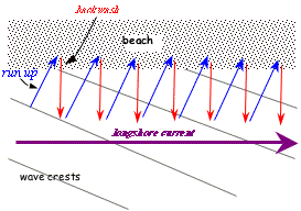 The run up moves with the wave perpendicular to the the wave crests and moves the wave onto the beach at an angle. The backwash runs that water back down the shore face perpendicular to the beach. Gravity pulls the water downslope, that is why it is perpendicular to the shoreface. This zig-zagging water movement (run up + backwash, over and over again) has an overall motion that is parallel to the beach; this parallel motion is the longshore current.
90% of the sand on the beach is delivered to the shore by streams. Once the sand gets delivered to the coast by the streams, it is distributed to beaches by the longshore current. Recall from last week what happened to the downstream delta when a river is dammed --> the delta shrinks and the sediment that once was redistributed to beaches is lost. So, damming also leads to shrinking beaches.
Protecting Against Coastal Erosion
In your group projects, you will examine the effectiveness of methods use to protect against coastal erosion. These methods range from the simple (planting vegetation on your beach) to the more complex (building seawalls and groins).
Seawalls
Seawalls are normally concrete structures built parallel to the shore (but may be made of piled up rocks or bulkhead timbers) in order to protect some structure behind it like seafront houses or roads. Seawalls are expensive to build and maintain and actually are a bad solution to the erosion problem because they intensify erosion in front of the wall.
A seawall absorbs wave energy, diverts the waves, and increases turbulence in front of the seawall. Thus, sandy beaches in front of seawalls tend to erode away and the shoreface in front of the wall beach becomes steeper which exposes the seawall to the full impact of storm waves (rather than having the waves gradually break as they would when a gently sloping beach is present - gently sloping beaches absorb wave energy gradually).
A seawall promotes erosion of existing sand by wave wash bouncing off of that wall.
riprap: a heap of large blocks of resistant rock piled seaward of the shoreline, similar to a seawall but less expensive (although it doesn't last as long as a concrete engineered seawall). Like a seawall, riprap absorbs the incident wave energy and promotes loss of the recreational beach in front of the riprap.
Groins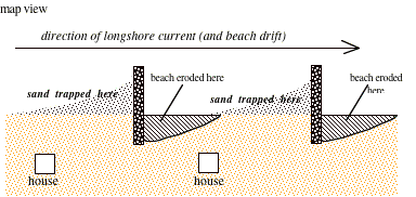
Groins are shore-protection structures built perpendicular to the shoreline to restore an eroding beach; they are usually rubble mound or rock (rip-rap) construction. Groins trap sand on the upcurrent side of the groin because they are a total to partial barrier to the longshore current (which, if you recall, carries both water and sand). Groins may trap sand on the up current side but they encourage erosion on their downcurrent side (remember, the longshore current is created by wave action, so as new waves come in on the downcurrent side, they pick up sand from the beach - that sand would normally be replaced by the sand carried from upcurrent, but the groin blocks that, so erosion is intensified on the downcurrent side).
Breakwaters
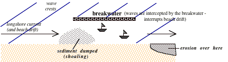 Breakwaters are walls placed offshore (parallel to the shorline) designed to intercept incoming waves to create quiet, wave-free zones - commonly used to protect boats at anchor. Breakwaters nearly eliminate wave action within the protected area - this interrupts the longshore current (and the sand it is carrying). Thus, there is not enough energy to move sand through the harbor and the beach begins to widen behind the breakwater. As we groins, erosion is promoted downcurrent as waves come in and erode sand which can not be replaced because the replacement sand is trapped behind the breakwater. Harbors commonly must pump sand out of the harbor and onto the downcurrent beaches.
Ocean Currents and Temperature
Here is some information that will be covered in this activity:
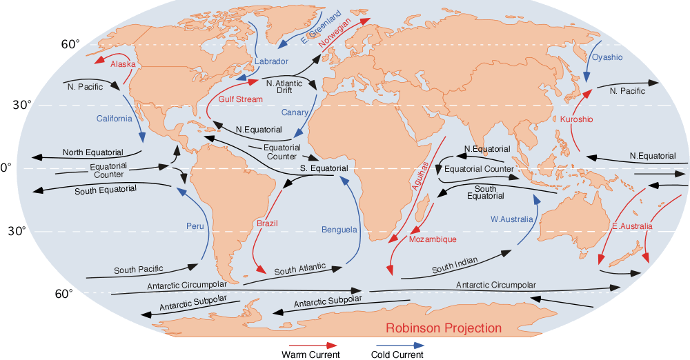
subtropical gyre: The large roughly circular motion of currents within an ocean basin (roughly betwen the equator and 50 or 60° north and south of the equator. Subtropical gyres consist of four currents: an eastern boundary current (that flows along the eastern boundary of the ocean basin), a western boundary current (that flows along the western boundary of the ocean basin), and two E-W oriented transverse currents. Please note that the terms 'eastern' and 'western' for the boundary currents refer to geographical directions relative to the center of the ocean basin - so put an E-W arrow in the center of the gyre before identifying eastern and western boundary currents. There are a total of five subtropical gyres in the: Indian, North Pactic, South Pacific, North Atlantic, and South Atlantic oceans basins. You can see the currents in each of these subtropical gyres in the surface current map on p.128 or at this url: http://www.physicalgeography.net/fundamentals/images/oceancurrents.gif.
Western boundary currents are generally faster and narrower than eastern boundary currents (which are slow and wide).
Western boundary currents move from the warm equator toward the poles, so they always carry warm water. Eastern boundary currents move from the cool polar areas toward the equator, so they always carry cool water.
Many of the links for this activity are no longer active - I will have hard copies available for your use in class.
Click here fore a some resources about ocean currents for elementary school children: http://www.windows2universe.org/teacher_resources/ocean_education/currents_main.html
If you miss week 15:
Read through the activities in your manual, e-mail Dr. Munn for a pdf of Why Gyres?. Contact Dr. Munn to arrange to make up the quiz that you missed (this must be done promptly because this was the last day of class). Worksheets collected for this lab will be listed on the Lab Schedule page must be turned as soon as possible (you may e-mail them to me). Click here for the syllabus information about missing class. I only collected one worksheet today: