Week 6: Volcanic Hazards
This week's activities:
- Eruption Types (154-162)
- Long Valley Analysis (p.163-165) - IF YOU HAVE ONE, PLEASE BRING YOUR LAPTOP TO CLASS TODAY
Click here to go directly to the links for the Long Valley Analysis activity.
Eruption Types
The type of volcanic eruption and the variety of volcano that forms depends in large part on the composition of the magma at the time of the eruption. Please read the background information about the concepts for this activity on p.154-156 of this activity; page 162 gives a brief overview of some volcano types.
Notes about Volcano Types and the Lava that forms them
Volcanoes Associated with Low Viscosity Basaltic Lava
Peaceful eruptions of low viscosity basaltic lava are commonly associated with shield volcanoes, cinder cones, and fissure eruptions
Shield Volcano
Shield volcanoes are large broad, and gently sloping (2° to 10° slopes) volcanic cones. The large volcanoes that make up the big island of Hawaii (Mauna Loa and Mauna Kea) are classic examples of shield volcanoes. The Hawaiian volcanoes erupt basaltic lava from rifts that radiate from the summit of the volcano and basaltic lava flows easily and spreads out broadly. Countless lava flows spread out and build up to tremendous heights by one on top of the other over time. For example, Mauna Loa’s circumference is about 400 miles and it has up to 6 miles of relief (if you start at its base, which is at the bottom of the ocean).
Fissure Eruptions
Fissure eruptions occur when basaltic lava erupts through linear fractures or fissures instead of from a round volcanic cone. Large-scale fissure eruptions are responsible for building the Columbia River Plateau up in Oregon and Washington (you can see the countless basalt lava flows that formed this geomorphic province in the Columbia River Gorge, for example). Small scale fissure eruptions are seen in rift zones that split the Hawaiian Shield volcanoes – like the East Rift Zone associated with Kilauea.
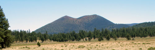
Cinder Cones
A cinder cone is a volcanic cone built of basaltic ash and cinders. When fluid basaltic lava fountains high in the air, the droplets of lava form the ash and cinders that build the cone as they fall to the ground. This fountaining lava is sometimes caused when basaltic lava encounters groundwater on its way to the surface. The hot lava superheats the groundwater causing it to flash to steam, which carries the lava up into the fountains that produce cinders and ash as the lava is thrown into the air. The finer-grained ash is blown downwind, and the larger heavier cinders fall around the vent to build up the cinder cone.
Cinder cones are the classically shaped volcanoes that you imagine when you think of a volcano. They are relatively small (height <1500 feet, typically 300 to 650 feet) with sides that slope at an angle of about 30°-40°. Cinder cones usually erupt over a short period of time (months to years) and during that time, once the steam that is causing the fountaining lava is used up, then massive basaltic lava flows breach the sides of the volcano. Once eruption stops, the cinders that make up the cone are easily eroded. Cinder cones usually only endanger property (lava flows and cinders are avoidable).
Examples: Paricutin, Mexico and Sunset Crater, Arizona - I went so see Sunset Crater a couple of summers ago (its a National Monument not far from Flagstaff). Here’s my photo:
Volcanoes Associated with High Viscosity Rhyolitic Lava
Explosive eruptions and pyroclastic flows associated with high viscosity rhyolitic lavas are commonly associated with stratovolcanoes and lava domes
Stratovolcano
Stratovolcanoes are tall volcanoes built from alternating layers of lava flows and pyroclastic material (from pyroclastic flows and ash fall). They are generally 1.5 to 2 miles high. Their elevation is so high that it is common to see a snowcap on its summit. Some even sport year-round glaciers.
Most stratovolcanoes form in subduction zones. The initial magma formed by partially melting the mantle in a subduction zone is basalt. But this magma commonly ends up becoming enriched in silica as it works its way up to the surface through the overlying thickened crust. The different layers in a stratovolcano indicate that different kinds of magma (varying from basalt to rhyolite) may erupt over its long life. The average composition of the magma in a stratovolcano is andesite, but composition varies depending on what happens to the originally basaltic magma on its way to the surface. Thus, stratovolcanoes exhibit a wide variety of eruption types over time (peaceful lava flows, explosive pyroclastic flows). Examples:
Mount Vesuvius in Italy
Mount St Helens in the U.S.
Mount Fuji in Japan
Mount Pelee in Martinique
Click here for a video about the 1980 eruption of Mount Saint Helens (a stratovolcano): http://www.youtube.com/watch?NR=1&v=xP2dreOI8gI
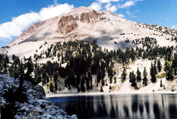
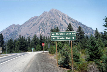
Lava Domes
Lava Domes are relatively small, rounded, steep-sided volcanoes that form from silica-rich rhyolitic magma. Lava domes form because this kind of lava (rhyolite) barely flows (extremely high viscosity), it just kind of bulges upward (instead of flowing outward). As the lava hardens it forms a plug, which traps gas below it. Lava domes are extremely dangerous because they tend to collapse and when they do, the pent up gas is released and forms nasty pyroclastic flows.
Most lava domes form in subduction zones. They may grow as separate isolated volcanoes (such as Lassen Peak, or Black Butte) or they may form within the crater of a stratovolcano (as has occurred in the crater of Mount Saint Helens) or even off the side of a stratovolcano (as in Shastina on Mount Shasta).
Some of my photos of Lava Domes:
Lassen Peak (in northern California; I think that I read somewhere that it is the largest volcanic dome in the world):
Black Butte (not far from Mount Shasta in northern California):
Long Valley Analysis
This activity involves internet-based research - bring your laptop if you have one. A few 8T laptops will be available if you don't have a lap top or forget to bring yours.
If you are unsure of how a caldera forms, here are some links that might help:
USGS photoglossary: Caldera: http://volcanoes.usgs.gov/vsc/glossary/caldera.html
Images for caldera formation:
http://volcano.oregonstate.edu/sites/default/files/Rodrigo1.jpg
http://intheplaygroundofgiants.com/wp-content/uploads/2013/07/Figure-2.2.8.jpg
Here are the links for the Long Valley Analysis activity:
History:
http://pubs.usgs.gov/fs/fs108-96/
http://www.dpc.ucar.edu/earthscopeVoyager/JVV_Jr/didyouknow/lvcVolcanoes.html
http://volcanoes.usgs.gov/lvo/about/history.php
http://volcanoes.usgs.gov/volcanoes/long_valley
http://volcanoes.usgs.gov/volcanoes/long_valley/long_valley_hazard_9.html
http://volcanoes.usgs.gov/volcanoes/mono_inyo_craters/mono_inyo_craters_geo_hist_20.html
Maps:
http://vulcan.wr.usgs.gov/Volcanoes/LongValley/Maps/map_long_valley.html
http://commons.wikimedia.org/wiki/File:CalderaRelief_large.gif
http://volcanoes.usgs.gov/volcanoes/long_valley/
General information on volcanic hazards:
http://pubs.usgs.gov/of/1995/0231/report.pdf
http://www.geo.mtu.edu/volcanoes/hazards/primer/
http://volcanoes.usgs.gov/Hazards/
General information on preparation:
http://www.emergencydude.com/volcano.shtml
http://www.ready.gov/volcanoes
TEPHRA
What is tephra and what are the hazards?
https://volcanoes.usgs.gov/volcanic_ash/ash.html
http://volcanoes.usgs.gov/hazards/tephra/index.php
http://www.geo.mtu.edu/volcanoes/hazards/primer/tephra.html
Aircraft Hazards:
https://volcanoes.usgs.gov/volcanic_ash/aviation.html
https://volcanoes.usgs.gov/volcanic_ash/ash_clouds_air_routes_effects_on_aircraft.html
http://pubs.usgs.gov/fs/fs030-97/
Actions to take for ashfall:
https://volcanoes.usgs.gov/volcanic_ash/what_can_i_do.html
http://www.muni.org/Departments/OEM/Prepared/Pages/VolcanicAsh.aspx
Tephra in the Long Valley Area:
http://volcanoes.usgs.gov/volcanoes/long_valley/long_valley_hazard_3.html
http://volcanoes.usgs.gov/volcanoes/long_valley/long_valley_hazard_7.html
http://volcanoes.usgs.gov/volcanoes/long_valley/long_valley_hazard_8.html
http://volcanoes.usgs.gov/volcanoes/mono_inyo_craters/mono_inyo_craters_geo_hist_10.htm
Air Routes Above Long Valley: http://volcanoes.usgs.gov/volcanoes/long_valley/long_valley_hazard_41.html
LAVA FLOWS AND LAVA DOMES
Effects of lava flows:
http://volcanoes.usgs.gov/hazards/lava/index.php
http://www.geo.mtu.edu/volcanoes/hazards/primer/lava.html
General information about lava domes: http://volcano.oregonstate.edu/book/export/html/443
Dangers of lava domes: http://volcano.oregonstate.edu/dangers-lava-domes
Other lava domes: https://www.e-education.psu.edu/geosc30/node/718
Lava Flows and Lava Domes at Long Valley:
http://volcanoes.usgs.gov/volcanoes/long_valley/long_valley_hazard_1.html
http://volcanoes.usgs.gov/volcanoes/long_valley/long_valley_geo_hist_19.html
http://volcanoes.usgs.gov/volcanoes/long_valley/long_valley_geo_hist_18.html
http://en.wikipedia.org/wiki/File:Long_Valley_Caldera_cross_section.jpg
http://volcanoes.usgs.gov/volcanoes/mono_inyo_craters/mono_inyo_craters_geo_hist_11.html
http://volcanoes.usgs.gov/volcanoes/mono_inyo_craters/mono_inyo_craters_geo_hist_16.html
PYROCLASTIC FLOWS
What is a pyroclastic flow?
http://volcanoes.usgs.gov/hazards/pyroclasticflow/index.php
http://volcanoes.usgs.gov/vsc/glossary/pyroclastic_flow.html
http://pubs.usgs.gov/of/1995/0231/report.pdf
Pyroclastic Flow Hazards:
http://volcanoes.usgs.gov/hazards/pyroclasticflow/
http://www.geo.mtu.edu/volcanoes/hazards/primer/pyro.html
http://www.geo.mtu.edu/volcanoes/hazards/primer/surge.html
Pyroclastic Flow Video: https://www.youtube.com/watch?v=Cvjwt9nnwXY
Long Valley Hazard Zones: http://volcanoes.usgs.gov/volcanoes/long_valley/long_valley_hazard_2.html
GASES
Effects: http://volcanoes.usgs.gov/vhp/gas.html
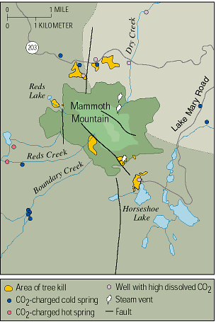
Gases at Mammoth Mountain:
http://volcanoes.usgs.gov/volcanoes/long_valley/long_valley_monitoring_59.html
http://pubs.usgs.gov/fs/fs172-96/
http://www.vulkaner.no/v/volcan/mammoth/co2treekill.html
http://volcanoes.usgs.gov/volcanoes/long_valley/long_valley_sub_page_23.html
Monitoring Gases at Mammoth Mountain:
ttp://volcanoes.usgs.gov/volcanoes/mammoth_mountain/monitoring_gas.html
http://pubs.usgs.gov/fs/fs172-96/images/Treekill.gif
EARTHQUAKES
General Info about Volcanic Earthquakes:
http://volcano.oregonstate.edu/how-are-volcanoes-and-earthquakes-related
http://www.geo.mtu.edu/volcanoes/hazards/primer/eq.html
http://www.learner.org/interactives/volcanoes/morfore.html
Info about earthquakes in the Mammoth area:
http://www.dpc.ucar.edu/earthscopeVoyager/JVV_Jr/didyouknow/lvcHazard.html
http://volcanoes.usgs.gov/volcanoes/long_valley/long_valley_monitoring_57.html
http://pubs.usgs.gov/bul/b2185/appenda.html (scroll down to the text and figures starting below figure A2)
http://earthquake.usgs.gov/monitoring/deformation/data/plots/map.php?region=LV (shows the faults in the Long Valley area)
If you miss week 6:
Read the material in your manual for each activity with care so that you understand what you missed, talk to a classmate to find out more, visit the internet sites for Long Valley Analysis. Worksheets collected for this lab will be listed on the Lab Schedule page and must be turned within a week. Click here for the syllabus information about missing class.
Please read the background information on p.154-156, that will help you with all of the worksheets that were collected. A pdf of the images used for the Volcanoes and Eruption Type activities is available on the SacCt site (click on 'pdf documents' in the left sidebar) - you will need this pdf in order to complete the worksheets from the manual (p.159, 162).
Here are more specifics about the worksheets that were collected:
- p.159 from the manual (second page of Magma Viscosity Worksheet)
- p.161 from the manual (second page of Volcanic Gas Worksheet)
- Volcanoes Worksheet