Week 11: More about the Weather
Please try to remember to bring your laptops to class today - we will be accessing sites on the internet.
Click here to do directly to the Weather Links.
This week's activities:
- Understanding Fronts (to be given to you in class)
- Weather Data/Weather Prediction (217-219)
- Hurricanes (p.220-222)
Understanding Fronts
Basic Information about Fronts
The stormiest, most changeable weather occurs along boundaries that separate two different temperature air masses. These boundaries are called fronts. It is very important to remember that whenever two air masses of widely different temperature meet, it is always the warm air that rises upward over the cooler air.
Why does the warmer air mass always rise up over the colder air mass?
That is because warm air is less dense than cold air.
The location of any front on a weather map is taken to be where the cold and warm air masses meet at ground level. No matter what the kind, any front usually brings bad weather! Doing the Understanding Fronts activity will help you better understand the interactions between cold and warm air masses at the different fronts and why clouds and precipitation differs at each.
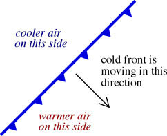 Cold Fronts
If a cooler air mass moves in and pushes against a warmer air mass, the boundary is called a cold front. The symbol for a cold front is a blue line with triangles on it pointing in the direction that the front is moving as shown in the diagram to the right. As the cooler air mass pushes forward, it cuts into the warm air mass at a steep angle forcing the warm air upward rapidly, making a narrow strip of tall storm clouds along the front as shown at this link: http://www.physicalgeography.net/fundamentals/images/coldfront.GIF. This cloud rises several miles vertically and, thus, concentrates the potential for rain over a small area (giving rise to heavy showers/thunderstorms).
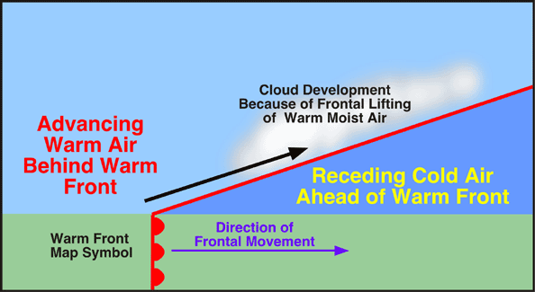
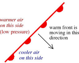 Warm Fronts
If warm air advances against cold air, the boundary is called a warm front. The symbol for a warm front is a red line with half circles on it pointing in the direction that the front is moving as shown in the diagram to the right. Friction with the ground slows down the cooler air mass so that it forms a gentle ramp over which the warmer air moves upward (see this link: http://www.physicalgeography.net/fundamentals/images/warmfront.GIF). This creates a broad area of cloud coverage which moves in advance of the front. Warm front clouds are thinner and spread out more horizontally than the tall clouds found at a cold front.
Weather Data and Weather Prediction
Click here for the US surface analysis map: http://www.intellicast.com/National/Surface/Mixed.aspx
Click here for the current US temperature map: http://www.intellicast.com/National/Temperature/TEMPcast.aspx
Click here for the current US radar map: http://www.intellicast.com/National/Radar/Current.aspx?location=MXBC0161
Click here for jet stream maps: https://weather.com/maps/travel/jetstreamwinds
See below for some alternative surface analysis and temperature maps:
Click here for a different US temperature map:http://www.intellicast.com/National/Temperature/Current.aspx?location=MXBC0161
Hurricanes
Hurricanes are terrible storms that can roam across thousands of miles of ocean and last for days (average length = 10 days). The universal term for these storms = "tropical cyclone". Tropical cyclones develop as rotating low pressure cells over tropical or subtropical water.
Recall that low pressure cells consist of warm air that is rising because it is less dense than the surrounding air. And, remember that rising warm air and clouds form as a result - thus, low pressure cells are commonly associated with clouds and potentially rainy weather.
Tropical cyclones rotate counterclockwise in the northern hemisphere and clockwise in the southern hemisphere and are blown by the prevailing winds. Local terms for tropical cyclones:
Hurricanes: North America and eastern Pacific
Typhoons: western Pacific, Japan, and southeast Asia
Cyclones: Indian Ocean, Southwest Pacific
Hurricanes get their energy from the ocean water because water has an unusually high heat capacity (as we discussed during the solar heating activity).
Heat Capacity: the amount of energy required to raise the temperature of a substance by one degree centigrade.
Water has a high heat capacity, therefore, it takes a great deal more energy to raise the temperature of water than it does to raise the temperature of other materials. Water molecules like to stick to each other, so it takes a lot of energy to get them unstuck from each other so that they can vibrate faster. So the water absorbs a lot of energy to get only a slight increase in temperature. In order to raise the temperature of water enough to get evaporation, an even larger amount of energy is required in order to get the molecules moving fast enough to break the sticky liquid water molecules apart from each other as water vapor.
Conversely, when water vapor condenses to make liquid water, all that heat energy is released when water vapor molecules come back together to form a liquid (energy is no longer needed to keep the molecules apart). This released energy is called latent heat and can power thunderstorms and hurricanes.
Latent Heat: the energy absorbed or released by water during a change of state.
The three states of matter are liquid, solid, and gas. Thus latent heat is stored and released as water changes form between these three states. The changes of state that are important for powering thunderstorms and hurricanes are:
Evaporation
Liquid --> Vapor (latent heat is absorbed in order to stay in the gaseous state)
Once again, when water is in its vapor form, a ton of energy is needed just to keep the vapor molecules separated from each other in their gaseous form (they like to stick together to make water, so energy has to be put into water to keep the molecules separated for evaporation).
Condensation
Vapor --> Liquid (latent heat is released because the water doesn't need it anymore to keep the water molecules apart)
When the water molecules stick back together to make water (condensation), they no longer need the energy that was keeping them apart - that energy is released during condensation in the form of heat
The primary ingredient for making a hurricane is a large source of warm water, minimum sea surface temperature must be 80°F (27°C) and it must be warm to a depth of at least 200 feet. The warmest water should be found in the tropics (between the Tropic of Cancer, the Equator, and the Tropic of Capricorn, depending on the season) because that is where the sun's rays are most perpendicular and thus most intense. This thick layer of warm water found near to the equator is a storehouse of energy. Hurricanes require vast quantities of warm moist air to stay alive.
When you heat an ocean up to 80°F, a lot of energy is stored in that water (because of water's high heat capacity). At temperatures of 80°F or greater, that water is ready to evaporate into the air at the slightest chance. When the warm ocean water evaporates, it absorbs energy.
In the tropics, warm ocean water evaporates up into air and is blown by the trade winds that converge from the north and the south which forces the vapor-rich air upward; the vapor brings its energy up with it (latent heat). As it rises, it cools and condenses to from clouds and the latent heat is released. So, cloud formation actually warms up the atmosphere. The warmer the atmosphere, the more it will continue to rise, the more it will cool, the more clouds that can be formed, the bigger the potential for building a big storm. Thus, if you have a lot of warm vapor-rich air rising, then you will have a lot of condensation and, therefore, lots of latent heat continually released to the atmosphere, keeping the air warm and expanding. The more the air expands, the lower the pressure will be, the faster the winds will blow into the center of the hurricane.
There are other requirements to form a hurricane but it all begins with the warm ocean water found in the tropics. Once a hurricane forms if it is cut off from its warm water source, it will die (this happens if it goes over land, or if it moves over colder ocean water).
Recap
The sun radiates energy to the earth and is most intense in the tropics. The energy is absorbed by and stored in the oceans. The warmed ocean water evaporates taking the energy (latent heat) up into the atmosphere. When the vapor eventually condenses, the energy (latent heat) is released to the atmosphere. The released heat keeps the atmosphere warm so that it can continue to rise causing lower and lower atmospheric pressure, faster winds, and greater rotation. Thus, the energy transfers from the ocean via evaporation and condensation drives all hurricanes (and other storms).
Click here for information about naming tropical cyclones:
http://www.nhc.noaa.gov/HAW2/english/basics/naming.shtml
http://www.srh.weather.gov/srh/jetstream/tropics/tc_names.htm
http://www.nhc.noaa.gov/aboutnames.shtml
Check out these websites for basic background information about hurricanes:
http://www.weatherwizkids.com/weather-hurricane.htm
http://environment.nationalgeographic.com/environment/natural-disasters/hurricane-profile/
If you miss week 11:
Look over the activities in your manual to get a feel for the material covered this week and read the information on this web page. Go to the internet sites for Weather Data and Weather Prediction (p.217-219; URL's linked above). Contact Dr. Munn to arrange to make up the quiz that you missed (this must be done sometime before the next class). Worksheets collected for this lab will be listed on the Lab Schedule page and must be turned within a week. Click here for the syllabus information about missing class. Here are more specifics about the worksheets that were collected:
• p.217-218 in your lab manual (Weather Data and Weather Prediction) - use the URL's linked on this web page above for this.
• p.222 in your lab manual (questions 1-4 of Hurricane Questions to Answer)
• Check Your Understanding: Fronts & Weather worksheet
If you want a copy of the Understanding Fronts activity that we did in class, it is available on SacCT (once you get ther, click on 'pdf documents' in the left sidebar).