Support Page Content
Geography Labs
Our Geography program works to provide students field opportunities in as wide a variety of natural and cultural environments as possible. We aim to instill in students the skill of observation, an appreciation for the importance of working with other cultures, and an understanding environmental and cultural relationships and processes.
The Department also hosts the campus’s Paleoecology Lab, but perhaps the most important facility is found outside—in the field. Our location in Sacramento provides our field courses access to a wide range of landscapes and environments relating to urban, rural, and physical geography.
Geographic Information Systems (GIS) Lab
The Geography Department is home for Geographic Information Systems (GIS) at Sacramento State. We aim to help students develop both a theoretical understanding of and practical experience using GIS that prepares them for the job market or graduate work. Our students have opportunities to develop these knowledge and skills in traditional lecture and lab courses in GIS, Remote Sensing, Cartography, Spatial Analysis, Data Acquisition & Management, and Programming. The department is also home to the Geospatial Lab @ Sac State, providing students GIS-focused employment opportunities via grants and contracts.
FACILITIES
The GIS facilities at Sacramento State expose students to industry standard GIS, Remote Sensing, and GPS hardware and software. The Geography Department's GIS labs have 30 PC dual-monitor workstations divided between instructional and student research labs, as well as color scanners and printers, two large format color plotters, and GPS receivers. Software includes a campus site license for ESRI’s ArcGIS products and other data analysis and productivity software such as R, SPSS/PASW, GeoDa, Adobe Creative Suite, and Microsoft Office.
Paleoecology Lab
The Sac State Geography Department is home to the CSUS Paleoecology Laboratory, located on the 3rd floor of Sequoia Hall. Established in 2004, the mission of the laboratory is to conduct environmental research furthering our understanding of past and present landscapes, and to promote student education and research. The Paleoecology Lab allows motivated students hands-on experience in field sampling techniques and laboratory processing and analysis of various environmental data. The Paleoecology's primary focus is on pollen and sedimentary charcoal analysis, with the goal of examining climate and environmental change over centuries to thousands of years.
FACILITIES
The Paleoecology Lab at California State University, Sacramento includes a compound microscope with 10x, 40x, and 100x objectives for pollen analysis, and a 10-40X Stereozoom binocular microscope with boom-arm and fiber optic illuminator for charcoal, macrofossil, and dendrochronology analysis. Numerous light microscopes and dissecting scopes are available for general student use. A Bartington MS2 magnetic susceptibility meter is available for sediment core analysis, and a 24” Travel Velmex Measurement System with 0.001 mm Accu-Rite readout for tree-ring work.
A variety of sieves ranging from 500 to 50 µm are available for recovery of macrofossils, charcoal, and artifacts from sediment and soil samples. The lab is also equipped with a 1.6 cubic ft laboratory oven for drying samples, a 127.5 cubic inch muffle furnace for loss-on-ignition analysis, and a desiccator for the storage of samples during analysis. A 5m by 1m refrigerator (4oC) provides for the long-term storage of sediment cores and soil samples.
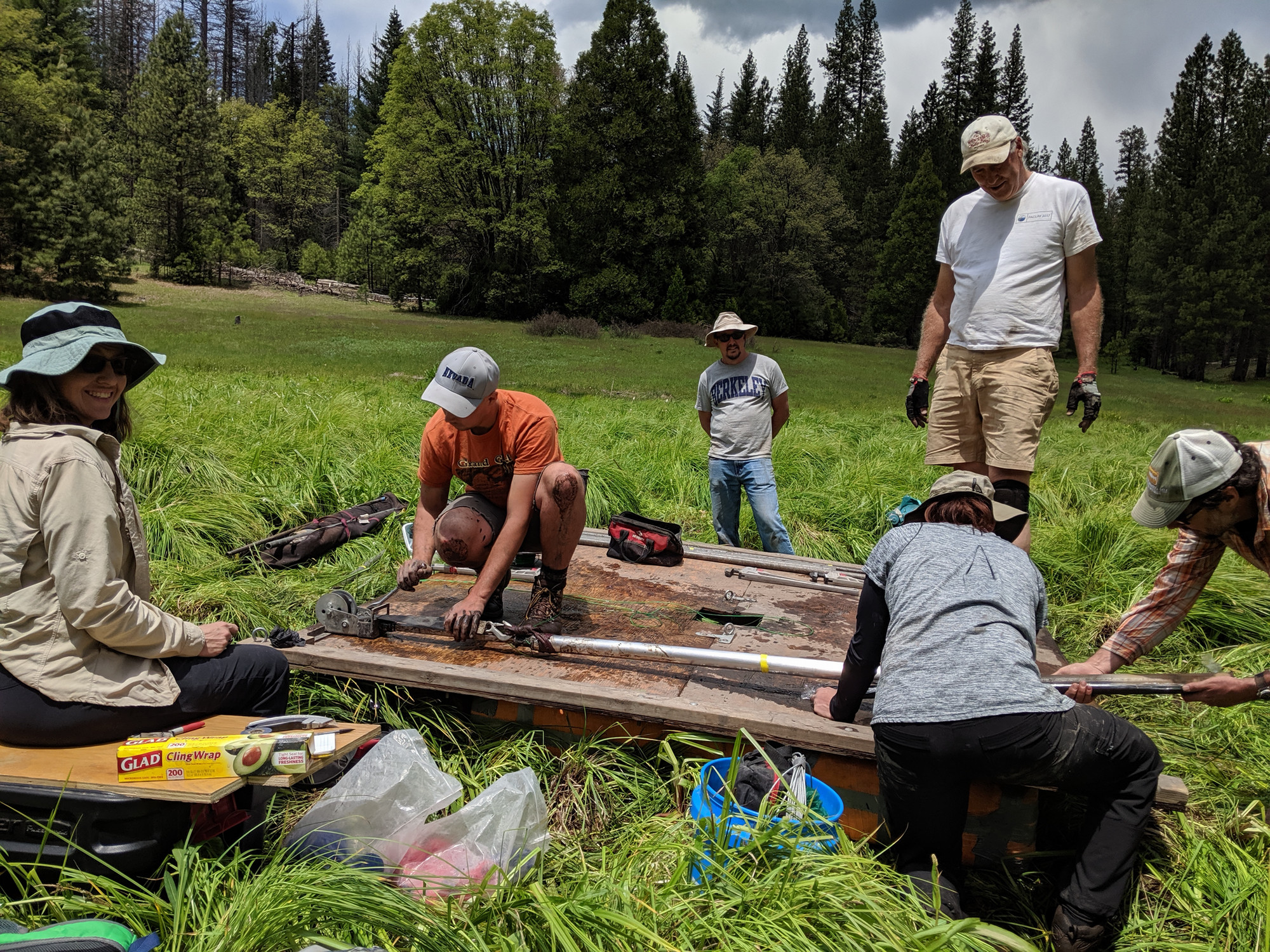
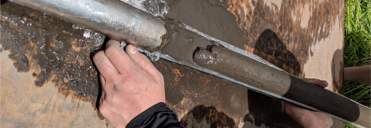
The lab is also equipped with field equipment for recovery of sediment cores and tree-ring samples, including two Livingstone-type square-rod piston corer with 50 m of¾ ” diameter steel rod, a 33"L Open-End Soil Sampler with 1-1/8" dia. and 13"L open slot, two floating platforms for recovering sediment cores from lakes and wet meadows (one suitable for sites that can be driven to, and another for packing into remote locations), and 10", 14”, 16”, and 20” Haglof tree increment borers
- About Sedimentology
Sedimentology is concerned with the use of lake and marsh deposits in reconstructing past environments. Layers of lake sediment can accumulate undisturbed over long periods of time, forming a repository of information about changing environmental conditions. When carefully collected and examined, these layers can be read like pages in a book describing the environmental history of a region. Sediment characteristics such as grain size, organic content, magnetic susceptibility, and elemental composition give insight into past climate and erosion in a watershed. The study of microfossils in lake sediments, such as pollen and charcoal, allows for the reconstruction of regional vegetation patterns and fire frequencies. Continuous sediment records spanning time periods from decades to hundreds of thousands of years have been used to study changing environments around the world.
- About Dendrochronology
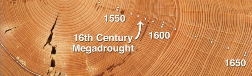
The science of dendrochronology is based on the doctrine that the "the past is the key to the future." By evaluating annual growth rings of suitable tree species we are given a glimpse of past environmental conditions. Knowledge of past environments helps us to better understand the environments in which we currently live and how these environments may change in the future. By evaluating changes in annual growth rings dendrochronologists are able to create records of environmental change that may extend back hundreds or even thousands of years. Tree rings have been used to study population dynamics of forests, volcanic eruptions, the rise and fall of ancient cultures, changes in insect and fish populations, earthquakes, tsunamis, river flow, atmospheric and soil pollution, deception in art masterpieces, radiocarbon dating, sunspots, and more.